Quotes

Life is short, break the rules. Forgive quickly, kiss slowly. Love truly, laugh uncontrollably and never regret anything that makes you smile. - Samuel Longhorne Clemens (Mark Twain)

Tuesday, August 31, 2021

Game Design Thoughts - Research and Books


I think the best part of doing the researching is acquiring the necessary research material. In this case I have acquired a number of "new" books. An 18XX game based on a more historical basis appeals to me more than one that is just another variant of 1830 or 1829. While I'm duly impressed with 18CO; Rocks and Stocks it lacks the elements that I'm looking for. The best way to help define those elements and then decide whether those elements are to restrictive takes some research which means scouring the internet (almost worthless for this subject, but not entirely) and finding some good books.

Thankfully I already had some of books to help get the project underway:

Tracking Ghost Railroads in Colorado by Robert Ormes (8th printing), Century One Press, Colorado Springs CO, 1980

Denver, South Park & Pacific by M.C. Poor, World Press, Denver CO, 1949 (limited edition #336/1000)

The Switzerland Trail of America by Forest Crossen, Robinson Press, Ft Collins Co, 1992 (softback), 2nd Edition

The DSP&P was probably the largest narrow gauge system after the D&RG and its history is fascinating. Its a dense book though coming in 493 pages including some maps (which are getting more and more fragile). If you are fan of Colorado Railroad history this is a cornerstone book and while its a limited edition its not really hard to come by if you are willing to spend some money. Mine, unfortunately doesn't have the dust jacket and I would like to acquire a copy that does.

The Switzerland Trail covers the history of the two railroads that headed west from Boulder CO (not at the same time). The Greeley Salt Lake & Pacific and later the Colorado & Northwestern. Its a good example of the trials and tribulations of many of the smaller mountain railroads that were built to tap the mineral wealth of the Rockies.

Tracking Ghost Railroads is an excellent guide to the physical locations of the railroads along with how to get there. I recommend a good 4WD vehicle if you plan on doing that you can drive on a lot of the old grades that way (the accessible ones anyway).

The new acquisitions are:

Railroads of Colorado; Your Guide to Colorado's Historic Trains and Railway Sites by Claude Wiatrowski, Farcountry Press, Helena MT, 2012

Colorado's Historic Mountain Passes by Larry Rynearson & Rick Jones, Western Reflections Publishing Co, Lake City CO, 1975

Colorado's Mountain Railroads by Robert A LaMassena, Sundance Publications, Denver CO, 1984

Rio Grande...To the Pacific by Robert A LaMassena, Sundance Publications, Denver CO, 1974, 2nd Edition

Colorado Central Railroad; Golden, Central City, Georgetown by Dan Abbott, Della A. McCoy and Robert W McLeod, Sundance Publications, Denver CO, 2007

The Midland Route; A Colorado Midland Guide and Data Book by Edward M. "Mel" McFarland, Pruitt Publishing Co, Boulder CO, 1980

The first two really came up bust for me, not nearly the kind of information I was looking for its hard when you have to buy them site unseen. The rest will form a solid core for the library. There will be more books on the D&RG the Rio Grand to the Pacific is a bit more focused on the Utah lines but does cover the split and recombination of the D&RG with the D&RGW.

The Colorado Central is an iconic railroad that was heavily involved in the early days of Colorado Railroading. More along the lines of the Switzerland Trail, it had big ambitions and always seemed to fall short due to money and circumstances. It would eventually become a part of the Colorado & Southern RR.

The Midland is fascinating, another railroad that struggled financially for its entire existence it was the first railroad to build standard gauge rails into the mountains and its system was quite extensive.

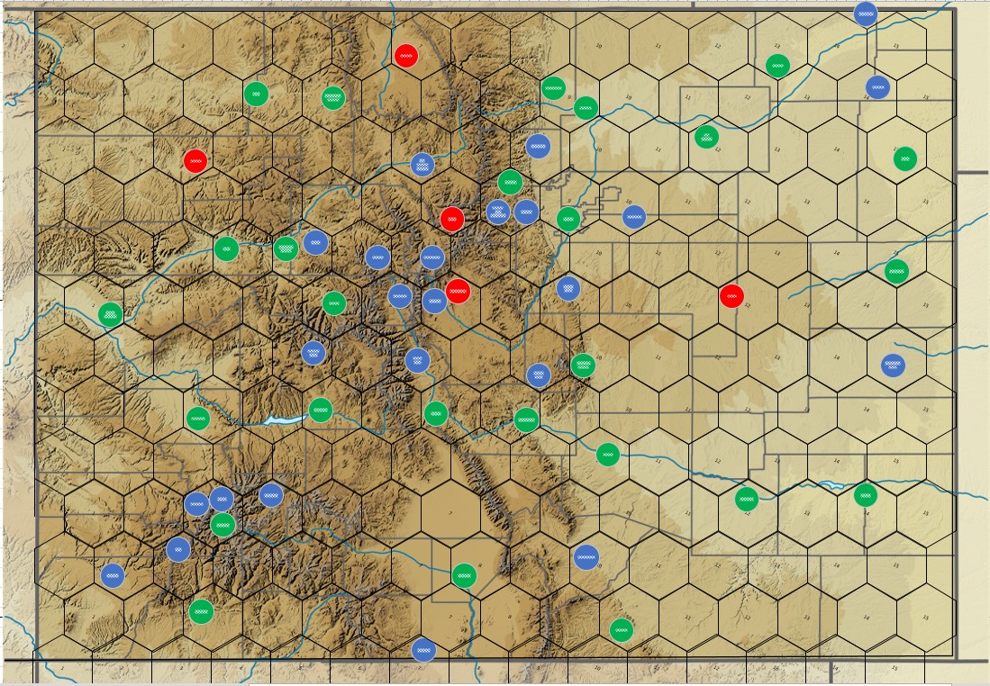
So far though, I think my best acquisition is the Colorado Railroad Map by Linn Westcott for Kalmbach Publishing from 1943. Shows all the railroads, the abandonments and topography. Its 78 years old and in amazing shape and I managed to get it for $20. Best buy so far.

With all of this I'm starting to refine the map and try and work through what railroads should be included, and how they will fit together. At the moment I'm considering keeping the number of public companies low supported by a lot of minor companies and maybe even more than your usual number of privates. I'm also sure that everything will not be available during the opening rounds so I'm considering an "event" deck similar to what Colin and I used in 1869. Events aren't random but are driving by the purchase of trains. Will see how it pans out.


The prize in the box, well eBay. I have been looking for this for a while. I have found reproductions available online but they don't include the information on the back of the map and they tend to be expensive, as do original copies like this one.

This is why the back of the map is as important as the front, a complete (yet to be determined) list of all the railroads in Colorado.

And the front. I knew that Linn Westcott was big in the model railroading world for a long time I had no idea he was a cartographer as well.

And perhaps the most interesting find, from the internet, is this:
National Register of Historic Places Multiple Property Documentation Form
A: Name of Multiple Property Listing - Railroads in Colorado 1858 - 1948
B: Associated Historic Contexts - The Historical and Technological Evolution of Colorado's Railroads 1858-1948
Prepared by Clayton B Fraser, Principal and Jennifer H Strand, Research Historian
Fraserdesign, 31 August 1997

This little gem helps tie everything together, almost 300 pages of information, it helps break Colorado railroading into distinct phases which is quite helpful when designing an 18XX game of any kind.

Thursday, August 26, 2021

Game Design Thoughts - The Map - First "Workable" Iteration


Here is the first iteration of the map that is approaching something that is at least workable. I'm sure there will be a lot of modifications to come. This one has a new image behind it and I'm pleased that I was able to pretty much remove the geological map I found and replace it with this relief map with almost no alteration. Just size it to fit. The added bonus with the relief map is I get enough of New Mexico to include Raton Pass and the southern bits of the D&RG route through northern NM and southern CO.

I like this image because it only includes the geographic features, no cities, no roads to deal with, just pure Colorado countryside. Each of the circles represents a town/city that may or may not be included. Red circles are included in other games (such as Rails through the Rockies and Tracks to Telluride) that I didn't think to include and I'm still unsure about including. Blue circles are towns/cities that I felt were important for historical railroad reasons, and green circles are common in all the games I looked at.

I know there are way to many cities on the board and probably at least half of them will have to come off. But one thing it does help identify is interesting geographic locations within the scale of the map. Two of the more interesting areas have three fairly important towns, from a railroad and/or revenue perspective all within the same hex. Lets start with the Denver area:


There are a lot of towns in this area that are geographically very close but fall into the "you can't get there from here" category. For instance to take the railroad from Denver to Dillon you would have to go south and come up through Fairplay to Breckenridge and then to Dillon.  There is a pass that would shorten that route; Loveland pass (because I don't think Argentine Pass is a viable route). I think that the route over the pass from the east is surmountable with a reasonable grade, but I'm fairly certain that the you couldn't get tracks down the western side. Its one of the areas that I'm trying to find old survey maps on, with little luck I might add. 

In addition you see two red circles in this area; South Park and Dillon. Just to be clear, there is no town or city in Colorado named South Park. There is an outdoor museum where a lot of historical buildings have been relocated to called South Park, but not an actual settlement by that name. Obviously that one will be removed. I believe that Dillon was only served by a spur so its likely going to be removed as well, even if I find a viable route north from that point, its just to close to Breckenridge which was more important from a railroad perspective.

Another interesting point is the hex containing; Golden, Boulder & Blackhawk. During the period the three only connected through Golden. Boulder was important, relatively speaking, because it was the gateway to Boulder canyon which had rich deposits of gold, silver and tungsten (which was important to the war effort in WWI). There was a railroad (the Colorado & Northwestern) that served the area and Boulder was the eastward terminus. Boulder was not part of any major routes north/south or east/west, Golden was important as the gateway up Clear Creek to the rich mining districts in Blackhawk/Central City and Georgetown/Silver Plume and a possible route across the Continental Divide. Not sure how I'll handle this hex, reduce it to one city or maybe keep two, something to mull about in my head for a bit.

Another interesting area is down in southwest Colorado in the Durango/Silverton area.


Silverton, Ouray and Telluride all exist in the same hex. But geographically you cannot go directly from one to another (well you can by car now, there is a highway between Ouray and Silverton but to get to Telluride you would have to take Black Bear Road from Red Mountain Pass, google that and you can see why they say 4WD only. You can still only get to Lake City through Montrose). In fact three little railroads would spiral out of Silverton, but only to serve the mines. In addition you can't really go from Lake City to Ouray or Silverton by rail either (I had a lengthy argument with another game designer that said from an engineering basis you could get a railroad up and over any terrain, which is certainly not true and even if you could would the financial outlay be balanced out by the potential income). Durango is the key here. There are rails through the Animas canon that will get your from Silverton to Durango but to get to Telluride you would then have to go through Dolores and Rico. From Telluride to Ouray you would have to go out of the hex again and come back through the adjacent side and Lake City is reached by a branch from an entirely different direction (I'm thinking through either Montrose or Gunnison, depends on which direction you are coming from). In theory you could put all three towns there and use a special tile to represent what's going on.

In the end some progress is being made. I probably should get back to the pass question before I start removing towns though.

This was the sign that was at the top of Red Mountain Pass. The sign was stolen so often the authorities stopped replacing it.


Thursday, August 19, 2021

Game Design Thoughts - Working the Map

This is the original logo that Colin and I devised for our line of 18XX games. We had grand plans!

There comes a time when you just have to buckle down and put something on paper, or in this case on the screen. For experimental purposes I'm doing this in Visio, not the greatest platform for this kind of thing but I'm very familiar with it and it will do the job, although ultimately not in a format really fit for publication, if I ever get that far.

One thing that makes the map process a little easier is the fact that Colorado is a rectangle with perfectly straight boundaries. None of the borders with the neighboring states following geographic features, like rivers, as a lot of state boundaries do. Colorado is the 8th largest state in the United States, the northern border follows the 41st line of Latitude and the 37th line of Latitude on the south. The eastern border is, basically, the 102nd line of Longitude and the western 109th line of Longitude (+/- a bit). The state measures 380 miles from east to west and 280 miles from north to south.

I decided that the easiest way to approach this was to decide on a scale for the 1 1/2" hex overlay, and I arbitrarily started with 25 miles, flat side to flat side. With that value set (the value "r" in the formula for hexagonal calculations) I could figure out how many, approximately, hexes I needed for the east-west dimension. The final result was 14 1/2 hexes. The north south is always more difficult to determine since you are measuring point to point, but you need to  consider the hex overlap so just dividing by 28.87 would get me in the ballpark. I ended up with 12 rows of hex running north-south which gives a rectangle that looks about right.

There are four major rivers that flow out of Colorado's Rocky Mountains; the South Platte, The Arkansas, the Rio Grande and the Colorado (originally named the Grand River important to know if you are looking at old maps). For now I'm ignoring the rivers, the reality is that only the Colorado River is a true obstacle, the others tend to only be obstacles during the spring run off. They will definitely be features on the map when (if?) I get that far with this little project. Then I need to add the cities, not something I was looking forward to.

To start I took the latitude & longitude for Denver and measured about where I would expect it to fall on the map, but didn't want to go through that process for all the towns and cities that might be needed. To make the process a little easier I found a geological map of Colorado from 1913. It solved the problem, it included towns and cities but didn't really show roads which tend to obscure details. It did, however, include the rail lines that existed in 1913 so I could see which towns I could consider including. What you find, which I think I knew in the back of my mind, is a north-south corridor of major cities along the front range and a concentration  of towns in areas of heavy mining or agriculture. 

This exercise allowed me rethink the towns I was thinking of including, some just didn't exist in 1913 or were to small to even be included. Some towns that I didn't think of including are important from a rail service standpoint and others are so clustered together that I will have to adjust their location or exclude them altogether, decisions, decisions. Back to the map. I downloaded a high resolution copy from the library and inserted as a picture into the Visio file I built. Using the picture as a background image I placed the hex grid over it and adjusted the size of the image to fit the borders I had determined. It actually worked really well, the proof being that Denver ended up almost exactly where I expected it to. I then used the map to pinpoint the towns/cities I wanted and within a couple of hours I had the beginnings of a useful map.

With the railroads printed on the geological map I think I can pinpoint the passes that were actually used, although they are not named on the map. I know most of them already its just a matter of translation. The hard part will be determining passes that were surveyed and could have been used and passes that were surveyed and were not viable routes. For instance Berthoud Pass was surveyed but not used, it would have required a 3.5 mile long tunnel to be a viable route, however Rollins pass (known as Boulder Pass at the time) was dismissed as a viable route in 1864 but construction began to in 1903 (and completed in 1904) to get over this "insurmountable" pass, while a 6 mile long tunnel (the famed Moffat tunnel) was built (construction on the tunnel didn't begin until 1920 and the first train rolled through in 1928). Things to ponder.

With thoughts of republishing 1869 I have fully transcribed the rules back into a word document. Now I need to start rebuilding the board. I just need the right software, something that would be equally useful the Colorado game.


Monday, August 9, 2021

Game Design Thoughts - Researching where the research is


I continue to work my way through what I consider to be one of the main features of any game, 18XX or otherwise, that features railroads in Colorado; mountain passes. I acquired a book last week, "Great Surveys of the American West" by Richard Bartlett, and while the focus was, indeed, on railroad surveys it was more on the surveys developed for the transcontinental railroad rather than the surveys for the railroads that would build into the Colorado Rockies. It is still an interesting book just not quite what I was looking for.

Another "book", more of a pamphlet really, provided quite a bit of useful information, but it would have been a lot more useful if it had included the map that had accompanied the original survey. The rather long winded title is "Union Pacific: Report of F.M. Case, of Surveys of Cache La Pondre & South Platte Routes and other Mountain Paeese in Colorado". And I intentionally left the misspellings in the title. Pondre should be Poudre (in Colorado we pronounce that as pooh-der) and Paeese should be Passes. Fortunately those errors were introduced by the printer that reproduced the report and you can find it all correctly spelled on the internet. Its quite a fascinating little document and it shows the difficulty in researching some subjects. For instance one of the passes explored (actually not explored) is Boulder Pass. On a modern map you are unlikely to find "Boulder Pass", with a little digging you will find Boulder Grand Pass in Rocky Mountain National Park but that's not the Boulder Pass in the report. The Boulder Pass mentioned in the report is what we now call Rollins Pass. Rollins pass was on the route used by the Denver & Salt Lake Railway before the Moffat Tunnel opened in 1927. The pass has had a number of names since its discovery including; South Boulder Pass, Boulder Pass and Corona Pass (I don't know which one is first, and Corona Pass seemed to be a later attempt to rename it from Rollins). I was verify the actual pass  from the USGS publication "Historic Trail Map of the Denver 1° x 2° Quadrangle, Central Colorado" by Glenn R Scott. There are a number of these historic trail map publications by Scott and I have most of them in PDF but I would love to get my hands on the physical publications (of course, no longer in print). Which brings me back to the map. There was a least one map that went with the F.M. Case survey report and perhaps two. Getting my hands on that map would help me determine if there is a viable railroad route into North Park from the Fort Collins area as he actually redlines potential railroad routes that may be worth surveying.

As I have mentioned before, in these game design ramblings, I do feel that the use of mountain passes and the restriction it causes in building viable routes is very important if you are going to capture the feel of railroading in Colorado. One of the things that bothers me with Ryan Driskel's "18CO, Rock & Stock" is how much track gets laid in northwestern Colorado and how little is laid in southwestern Colorado based on the in-game progress pictures that I  have seen posted. Granted I'm restricted to what has been posted, but like a lot of 18XX games there are patterns that tend to be very consistent. To be fair I have not played Ryan's version yet so I don't have first has hand experience with his game at this point. I am viewing  it from the lens of how the railroads developed in Colorado and development in the northwest was very light and it occurred very late in the Colorado's development. I back this up from a document I found written for the United States Department of the Interior National Park Service titled "Railroads in Colorado 1858-1948. There is a sequence of maps in this document that shows the development of the rail network in Colorado.

1870 Map
All maps are screen shots from the Department of Interior Document and originally appear in the Encyclopedia of Western Railroad History by Donald B. Robertson

1875 Map

1880 Map

1885 Map
Finally a connection to the west, but not a true transcontinental route as it connects Grand Junction with Denver via the Denver & Rio Grande and then to points east over the larger railroads like the Union Pacific.

1890 Map

1910 Map
This is the first map that we see activity in the northwestern portion of the state. The Denver & Salt Lake Railroad opens in 1902 and crosses Rollins pass in 1903 to finally break into northwestern Colorado looking for a more direct route to Salt Lake City. It never advances beyond Craig 

1915 Map
This is pretty close to a "finished" version of the rail network in Colorado. After this there are mostly realignments, mergers and major abandonments.

This sequence of maps reveals a couple of things; the development of the rail network was primarily north to south in the early years, then expanding east to west to create a secondary transcontinental route which would eventually hook back up with the Union Pacific in Utah. The mining industry was the big driver for the railroads, first for silver (central Colorado), then for gold (central and southwest Colorado) and later for coal (northwest Colorado). The question becomes how to really drive an 18XX game to achieve something that is both somewhat historical and fun to play. And those are only the first elements that need to be dealt with. I'm still thinking that the map needs to come first and then the rest can follow.