Here is the first iteration of the map that is approaching something that is at least workable. I'm sure there will be a lot of modifications to come. This one has a new image behind it and I'm pleased that I was able to pretty much remove the geological map I found and replace it with this relief map with almost no alteration. Just size it to fit. The added bonus with the relief map is I get enough of New Mexico to include Raton Pass and the southern bits of the D&RG route through northern NM and southern CO.
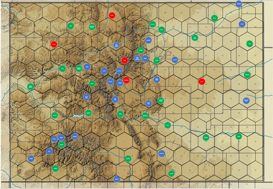
I like this image because it only includes the geographic features, no cities, no roads to deal with, just pure Colorado countryside. Each of the circles represents a town/city that may or may not be included. Red circles are included in other games (such as Rails through the Rockies and Tracks to Telluride) that I didn't think to include and I'm still unsure about including. Blue circles are towns/cities that I felt were important for historical railroad reasons, and green circles are common in all the games I looked at.
I know there are way to many cities on the board and probably at least half of them will have to come off. But one thing it does help identify is interesting geographic locations within the scale of the map. Two of the more interesting areas have three fairly important towns, from a railroad and/or revenue perspective all within the same hex. Lets start with the Denver area:

There are a lot of towns in this area that are geographically very close but fall into the "you can't get there from here" category. For instance to take the railroad from Denver to Dillon you would have to go south and come up through Fairplay to Breckenridge and then to Dillon. There is a pass that would shorten that route; Loveland pass (because I don't think Argentine Pass is a viable route). I think that the route over the pass from the east is surmountable with a reasonable grade, but I'm fairly certain that the you couldn't get tracks down the western side. Its one of the areas that I'm trying to find old survey maps on, with little luck I might add.
In addition you see two red circles in this area; South Park and Dillon. Just to be clear, there is no town or city in Colorado named South Park. There is an outdoor museum where a lot of historical buildings have been relocated to called South Park, but not an actual settlement by that name. Obviously that one will be removed. I believe that Dillon was only served by a spur so its likely going to be removed as well, even if I find a viable route north from that point, its just to close to Breckenridge which was more important from a railroad perspective.
Another interesting point is the hex containing; Golden, Boulder & Blackhawk. During the period the three only connected through Golden. Boulder was important, relatively speaking, because it was the gateway to Boulder canyon which had rich deposits of gold, silver and tungsten (which was important to the war effort in WWI). There was a railroad (the Colorado & Northwestern) that served the area and Boulder was the eastward terminus. Boulder was not part of any major routes north/south or east/west, Golden was important as the gateway up Clear Creek to the rich mining districts in Blackhawk/Central City and Georgetown/Silver Plume and a possible route across the Continental Divide. Not sure how I'll handle this hex, reduce it to one city or maybe keep two, something to mull about in my head for a bit.
Another interesting area is down in southwest Colorado in the Durango/Silverton area.

Silverton, Ouray and Telluride all exist in the same hex. But geographically you cannot go directly from one to another (well you can by car now, there is a highway between Ouray and Silverton but to get to Telluride you would have to take Black Bear Road from Red Mountain Pass, google that and you can see why they say 4WD only. You can still only get to Lake City through Montrose). In fact three little railroads would spiral out of Silverton, but only to serve the mines. In addition you can't really go from Lake City to Ouray or Silverton by rail either (I had a lengthy argument with another game designer that said from an engineering basis you could get a railroad up and over any terrain, which is certainly not true and even if you could would the financial outlay be balanced out by the potential income). Durango is the key here. There are rails through the Animas canon that will get your from Silverton to Durango but to get to Telluride you would then have to go through Dolores and Rico. From Telluride to Ouray you would have to go out of the hex again and come back through the adjacent side and Lake City is reached by a branch from an entirely different direction (I'm thinking through either Montrose or Gunnison, depends on which direction you are coming from). In theory you could put all three towns there and use a special tile to represent what's going on.
In the end some progress is being made. I probably should get back to the pass question before I start removing towns though.
 |
| This was the sign that was at the top of Red Mountain Pass. The sign was stolen so often the authorities stopped replacing it. |
No comments:
Post a Comment